
Fortell venner om denne varen:
Annapurna, Nepal: Travel Maps International Adventure Map
National Geographic
Bestillingsvarer

Annapurna, Nepal: Travel Maps International Adventure Map
National Geographic
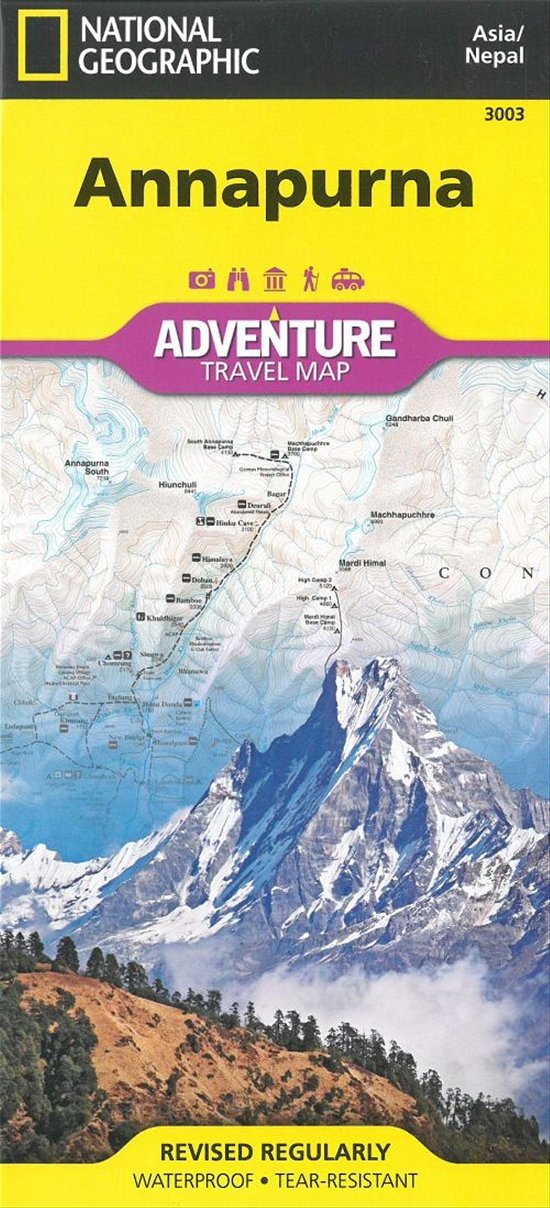
National Geographic´s Annapurna, Nepal AdventureMap is designed to meet the unique needs of adventure travelers with its durability and accurate information. This folded map provides global travelers with the perfect combination of detail and perspective, highlighting hundreds of points of interest and the diverse and unique destinations within the country.
The map includes the locations of cities and towns with a user-friendly index, plus a clearly marked road network complete with distances and designations for major highways, main roads, and tracks and trails for those seeking to explore more remote regions. This detailed trekking map includes routes from Pokhara along the Marsyandi River, Thorung Pass, and the Kali Gandaki River in the Annapurna Conservation Area.
Every AdventureMap is printed on durable synthetic paper, making them waterproof, tear-resistant and tough - capable of withstanding the rigors of international travel.
1 pages, illustrations
| Media | Bøker Landkart (Land- eller sjøkart) |
| Utgitt | 2. august 2012 |
| ISBN13 | 9781566955218 |
| Utgivere | National Geographic Maps |
| Genre | Maps & Guides |
| Antall sider | 1 |
| Mål | 110 × 233 × 6 mm · 84 g |
| Språk | Engelsk |
Mer med National Geographic


![Cover for National Geographic · National Parks Of The United States (Landkart) [2023rd edition] (2023)](https://imusic.b-cdn.net/images/item/original/519/9781566957519.jpg?national-geographic-2023-national-parks-of-the-united-states-landkart&class=scaled&v=1614256782)


![Cover for National Geographic · Food Journeys of a Lifetime 2nd Edition: 500 Extraordinary Places to Eat Around the Globe (Innbunden bok) [2nd Edition, Revised edition] (2022)](https://imusic.b-cdn.net/images/item/original/481/9781426222481.jpg?national-geographic-2022-food-journeys-of-a-lifetime-2nd-edition-500-extraordinary-places-to-eat-around-the-globe-innbunden-bok&class=scaled&v=1648793919)


Andre har også kjøpt


![Cover for Michael Bo Christensen · USA – nationalparkernes land (Heftet bok) [1. utgave] (2024)](https://imusic.b-cdn.net/images/item/original/265/9788743601265.jpg?michael-bo-christensen-2024-usa-nationalparkernes-land-heftet-bok&class=scaled&v=1709959205)
![Cover for James Joyce · Ulysses (Innbunden bok) [1. utgave] [Indbundet] (2014)](https://imusic.b-cdn.net/images/item/original/584/9788763814584.jpg?james-joyce-2014-ulysses-innbunden-bok&class=scaled&v=1412192648)
![Cover for Stephen Fry · Troja (Innbunden bok) [1. utgave] (2021)](https://imusic.b-cdn.net/images/item/original/138/9788770075138.jpg?stephen-fry-2021-troja-innbunden-bok&class=scaled&v=1628083478)
![Cover for Minette Walters · Mursejleren og rørhøgen (Innbunden bok) [1. utgave] (2022)](https://imusic.b-cdn.net/images/item/original/562/9788770076562.jpg?minette-walters-2022-mursejleren-og-roerhoegen-innbunden-bok&class=scaled&v=1657231213)
![Cover for Martin Jensen · Kong Knud: Kongens køtere Bind 2 (PB) (Pocketbok) [1. utgave] (2020)](https://imusic.b-cdn.net/images/item/original/114/9788772042114.jpg?martin-jensen-2020-kong-knud-kongens-koetere-bind-2-pb-pocketbok&class=scaled&v=1583905957)
![Cover for Martin Jensen · Økser over England (Heftet bok) [1. utgave] (2022)](https://imusic.b-cdn.net/images/item/original/891/9788772046891.jpg?martin-jensen-2022-oekser-over-england-heftet-bok&class=scaled&v=1654257447)
![Cover for Martin Petersen · På Djævelens tilskyndelse (Heftet bok) [1. utgave] (2016)](https://imusic.b-cdn.net/images/item/original/662/9788711630662.jpg?martin-petersen-2016-paa-djaevelens-tilskyndelse-heftet-bok&class=scaled&v=1475338447)
![Cover for Vivian Etting · Margrete 1. (Innbunden bok) [4. utgave] (2021)](https://imusic.b-cdn.net/images/item/original/866/9788702322866.jpg?vivian-etting-2021-margrete-1-innbunden-bok&class=scaled&v=1620539515)
![Cover for Bergsveinn Birgisson · Den sorte viking (Heftet bok) [1. utgave] (2022)](https://imusic.b-cdn.net/images/item/original/923/9788702263923.jpg?bergsveinn-birgisson-2022-den-sorte-viking-heftet-bok&class=scaled&v=1636652110)
![Cover for Jeanette Varberg · Fortidens slagmarker (Innbunden bok) [1. utgave] [Indbundet] (2014)](https://imusic.b-cdn.net/images/item/original/804/9788702083804.jpg?jeanette-varberg-2014-fortidens-slagmarker-innbunden-bok&class=scaled&v=1400041825)

Se alt med National Geographic ( f.eks. Pocketbok , Innbunden bok , Bok , DVD og Landkart )